Hiking - Crêt de la Perdrix "Heart of the Pilat" - Graix No. 4
The area of GRAIX (from the Latin grésum: rocky ground) covers 860 hectares, composed of meadows, pastures, fields, heathland, and woods: conifers and deciduous trees (nearly 400 ha).
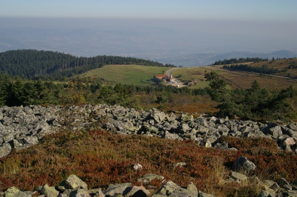
The altitude of Graix ranges from 870 m to 1,432 m. Crêt de la Perdrix, the highest point in the Pilat massif, is located within the municipality. It is a fantastic viewpoint: to the north lie the Monts du Lyonnais, to the west the Forez mountains, to the south the Ardèche mountains, and to the east the Rhône Valley and the Alps. There are also beautiful views of Mézenc and Gerbier-de-Jonc.
The municipality is situated on the southern slope of the Pilat massif and therefore enjoys plenty of sunshine. Nature here is preserved and the landscape is unspoiled, creating a sense of calm and serenity that is ideal for both relaxation and hiking.
This loop trail takes you to Crêt de La Perdrix, the highest point in the Pilat massif at an altitude of 1432 m.
Follow the D8 road towards Colombier. At the Graix sign, take the wide, steep path on the left. When you reach Grangeneuve (a small hamlet), keep the houses on your right. Then, take a rising paved path that emerges near La Vourzie on the Jarlées plateau, close to the Dévalkart track. From there, you have a magnificent view south towards the various Ardèche mountain ranges and, at times, the Alps.
Reach and cross the road from l'Oeillon to Réalles; the small road becomes a forest track. Continue climbing through the forest in the same direction, and you will soon reach both the road to La Jasserie and the GR7 trail.
You will soon reach the heathland at Crêt de la Perdrix (1,432 m, the summit of the massif). A stop is a must to enjoy the vast panorama (there is a viewpoint indicator).
Follow the GR7 for a short distance through the rocks (steep descent), then carefully follow the yellow and white trail markers.
When you reach the Parc du Pilat sign, turn right towards Saint-Sabin (Parc trail). Continue following the signs for Saint-Sabin.
Then, descend to the right (yellow and white markers) into a beautiful forest; the path is rocky in places.
This path leads you to La Loge (a house) and meets the D63 road near the Croix de La Loge. Cross the D63 and continue on the small road opposite. 400 m further, at the junction with the Route du Prince du Vernay, take a path on the right descending into the forest. Then, take a path on the left that leads to the Graix bridge (D8 road). Follow this road up (on the right) to return to the village.
All hikers are responsible for their own safety. Therefore, you undertake this hike at your own risk. Please stay on the marked trails to protect fragile environments.
A few recommendations:
- Check the weather forecast before you set off
- Some routes cross busy roads: Be careful
- Keep dogs on a leash
- Do not light any fires
- Take your rubbish with you
- Enjoy the flowers, but do not pick them.
- Tick bites can lead to serious illnesses. To prevent them: wear long clothing, use repellents, check your body upon your return, remove ticks with a tick remover tool without applying any substance, and consult a doctor if redness or flu-like symptoms appear, or if you are in a high-risk group.
- For emergency services, dial 18 or 112.