Hiking - Mongioie
A dirt track and an easy trail lead to Rifugio Mongioie, a very popular destination for hikers. The trail continues, easy to follow although steep in sections, up to Bocchino dell'Aseo. The final part of the ascent follows a very steep track.
Given the considerable elevation gain, this hike passes through all the typical environments of the Ligurian Alps: the forests surrounding Viozene, vast pastures around Rifugio Mongioie, then patches of pine trees, and finally, white limestone rocks on the ascent to Mongioie. The view from the summit of Mongioie, the second highest peak in the Ligurian Alps, is exceptional.
The trail begins in Viozene (1242 m), behind the Parish Church. A steep concrete ramp leads to a small paved road, which you follow uphill to the right (fountain).
Past the last houses of the village, the road continues as a dirt track. Ignore a branch to the right and you will come to a clear junction, where you follow the signs to the left for the "Sentiero Natura". A little further on, the dirt track ends at a renovated cabin.
Continue on the trail to the right of the building; ignore a first track on the left that descends back towards Viozene, then, at the next fork, keep right (the left track is a shortcut). The path climbs quite steeply, with a few turns; pass the "Cabana de Cian Ruscet" on your right and, now out of the woods, you will reach the wide pastoral plateau of Pian Rosso.
At the next crossroads, ignore on your right both the junction for Bocchino dell'Aseo and Mongioie (an option for those who want to bypass the refuge) and the one for Pian del'Arma. Instead, turn left (west) and you will soon reach Rifugio Mongioie (1550 m, 0:55 hours from Viozene).
Just before the fence surrounding the refuge, the trail to Bocchino dell'Aseo branches off to the north-northeast. Almost immediately, ignore a junction on the left, and you will rejoin the trail from Viozene that you left shortly before the refuge.
Following it to the left, you traverse grassy scree slopes dotted with sparse vegetation; then, after crossing a gully, ignore the path branching off to the left for Bocchino delle Scaglie. You now enter the very steep Vallone della Vastera, climbing with tight switchbacks alternating with short, steep traverses through a small pine wood.
Beyond the grove, after a few wide bends and a steep traverse, the trail turns right (east) and levels out, before a new series of switchbacks (spring 10m to the right of the trail at approx. 2035 m) leads up to the grassy basin of Pian dell'Olio.
The path crosses the basin on its orographic right side and then resumes a steep climb to get over a rocky ledge that seems to close off the valley between imposing limestone walls. However, the valley then opens up, and an easy path reaches Bocchino dell'Aseo (2295 m, 2:20 hours from Rifugio Mongioie), a wide pass connecting the Tanaro Valley with the head of the Corsaglia Valley.
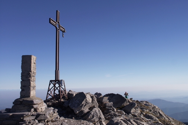
A few meters before Bocchino dell'Aseo, a signpost on the left indicates the start of the trail to the summit of Mongioie. The route is far from monotonous, alternating between sections with tight switchbacks, stepped rocky sections, and traverses. However, the steep gradient, the scree that makes the ascent more challenging, and the ever-widening views are constant features. Once on the ridgeline, follow it to the left (south-southwest) over rocky ground for a few dozen meters until you reach the cross on the summit of Mongioie (2630 m, 0:50 hours from Bocchino dell'Aseo).