Hiking - Passo and Cima delle Saline
The trail remains on easy terrain all the way to Passo delle Saline, although sudden fog (not uncommon in summer) can make orientation difficult. The ascent to Cima delle Saline is more demanding, not so much for its technical difficulty as for its considerable and constant gradient.
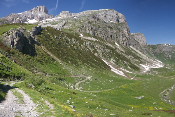
The route winds through alpine meadows and pastures up to Passo delle Saline. It crosses one of the areas that best displays the typical features of karst phenomena, from water erosion on the limestone rocks to the various sinkholes visible along the way. The panorama from Cima delle Saline is also excellent.
From Porta di Pian Marchisio (or Pian Marchisa, 1634 m), follow the dirt road that descends into the wide grassy plain of Pian Marchisio and continues almost level alongside the Ellero Stream.
With two hairpin bends (each cut by short shortcuts to the left), the track climbs, passing on the right the path leading directly to the refuge and a farm road, before splitting.
Take the left fork, crossing the stream on a concrete bridge.
The dirt road continues almost level, then fords the stream twice as it flows along the valley floor.
Just beyond Gias Pra Canton, the track climbs a rocky step with a couple of bends, reaching the junction on the right for the trail to Passo delle Saline.
Follow this path as it continues up the rocky step through a small gully, emerging onto the plateau above near the ruins of a gias and the Inghiottitoio del Tumpi. A faint track across the meadows (marked by posts) runs beside a long, almost straight rocky outcrop; keeping it on your left, climb up again until you reach broad alpine pastures (in this section the limestone erosion features on the exposed rocks are quite evident).
The trail (still marked by posts) bends to the right and climbs the slope, first with a few switchbacks, then along a steep traverse. A level section leads further right (southwest), crossing a wide grassy basin at the foot of Passo delle Saline.
The final slope is steep, partly due to ill-advised shortcuts; only near the top do easier switchbacks reappear, leading up to Passo delle Saline (2177 m, 2:10 h from Porta di Pian Marchisio).
At the pass, take the path branching off to the right. Soon it becomes a faint but very steep track with tight switchbacks, keeping fairly close to the watershed. The track, almost always visible, climbs steadily over fine scree and small rocks to the base of a prominent rocky rise that seems to block the way. By veering slightly left, you can follow a broad ledge that allows you to overcome the last few dozen metres of ascent leading to the summit of Cima delle Saline (2613 m, 1:15 h from Passo delle Saline).