Hiking - The Manolino Hut
Unfortunately, recent logging tracks have erased long stretches of the trail, although they have made the climb easier and the route more evident in some sections.
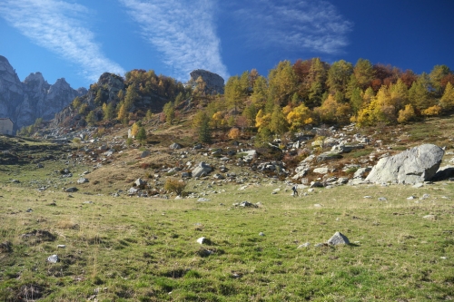
The trail winds for the most part through a dense forest, opening up only in the beautiful pasture basin of Alpe di Perabruna, home to the Manolino Social Hut. The autumn colors are magnificent, while midsummer may be best avoided due to the many herds grazing in the area.
Cross the Ponte della Marmorea (or Ponte della Marmorera, 1058 m) over the Rio di Moscardina (or Rio di Valcalda), and immediately afterward ignore the dirt road (private) branching off to the right. Keep to the left and continue gently uphill on a dirt road.
The route climbs up Valcalda through mixed woodland, following the left orographic bank of the Rio di Moscardina. After a concrete-floored ford, the road crosses to the right bank of the stream and continues with a moderate ascent.
After two close hairpin bends and another traverse, at the next left-hand bend leave the dirt road and follow the path branching to the right into the beech forest. It soon reaches the Rio di Moscardina again, crossed on a precarious log footbridge to return to the left bank.
A short section through the beech woods leads to another crossing of the stream, this time aided only by a rope stretched between the banks. The path then climbs along the right side of the valley before rejoining the dirt road left earlier; follow it to the nearby bend, where the path branches off again to the right. The ascent continues to the wide clearing of Pian Marlà (or Pian Marta, 1440 m, 1 hr 15 min from Ponte della Marmorea), where the road is met once more.
Turn right and, leaving the clearing, cross the small Rio di Perabruna; the dirt road climbs steeply at first, then splits into two tracks. Take the right-hand one, which soon becomes a path skirting the edge of the splendid pasture basin of Alpe di Perabruna.
Now fully out of the forest, the path curves right past the ruins of a large cowshed, with the lower Cella di Perabruna a little higher up to the left. Overgrown with nitrophilous vegetation, the path heads north-northwest, crosses yet another stream, and climbs the slope of a rounded grassy hill.
Beyond the stream, the (sparse) waymarks reappear, but the path becomes faint and mingled with cattle tracks. In a broad left-hand arc across the meadows, it turns south again, and near a huge boulder the path becomes clear once more, climbing the panoramic knoll where the Manolino Social Hut stands (1628 m, 40 min from Pian Marlà).