Hiking - La boucle du Pis du Pesio
Small, sometimes narrow but well-marked trails alternate with comfortable mule tracks on this short but satisfying loop.
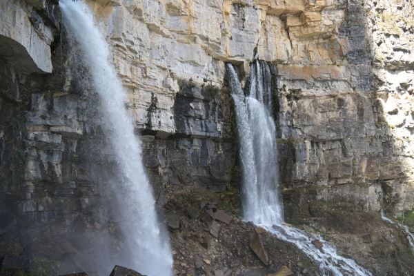
The Pis du Pesio is a spectacular waterfall where water gushes directly from a vertical rock face, plunging more than 20 meters. This phenomenon is as fascinating as it is ephemeral: it only occurs for a few weeks a year, in spring, when meltwater fills the underground cavities, causing them to overflow through the Pis's terminal siphon. The magnificent beech and fir forests, along with other waterfalls, add to the appeal of this very interesting route.
At Pian delle Gorre (1032 m), take the dirt road to the right of the refuge of the same name. The dirt road immediately turns into a comfortable mule track, runs through a fir forest, and crosses a bridge over the stream flowing down from the Vallon du Saut.
Here, get on a dirt track and follow it to the right. Cross a second bridge and head downhill along the stream. Near a wider section, the track turns left and follows the Pesio Stream. Before the next bridge, take the trail on the left towards Gias Fontana and the Pis du Pesio.
The trail follows the stream, with a path forking off to the right towards the Canavere Wildlife Observatory, then climbs steeply southwards with several switchbacks, reaching Gias Fontana (1218 m, 55 min from Pian delle Gorre). At the gias, ignore the trail on the right heading to Col du Baban.
If you wish, you can take a short detour of a few minutes towards Col du Baban to also admire the beautiful Gias Fontana waterfall. Keep left to enter a beech forest, and climb via traverses and steep sections to a fork: the left path continues to Gias des Arpi, the right to the Pis du Pesio.
Go right and climb to the foot of the Pis du Pesio waterfall (1410 m, 40 min from Gias Fontana).
Retrace your steps, and this time keep left, continuing until you get on the former military mule track that connects Pian des Gorre and Col du Prel.
Follow the mule track to the left, on a gentle but steady descent, which ends much lower down in the Vallon du Saut. After crossing a stream via a wooden footbridge, you will reach a fork: climb to the right, immediately ignoring the bridge on your left, onto a narrow, obvious path that leads to the first of the two Saut Waterfalls (1222 m, 1h 05min from the Pis du Pesio). After another wooden bridge, you will reach the second waterfall, then descend quickly back to the old former military mule track you left shortly before.
Continue on the mule track to the left until you reach a wider section where a comfortable dirt road joins from below. Follow this road downhill to return to Pian des Gorre (1032 m, 25 min from the Saut Waterfalls).