Hiking - The Cotatay Dam - Le Chambon-Feugerolles No. 6
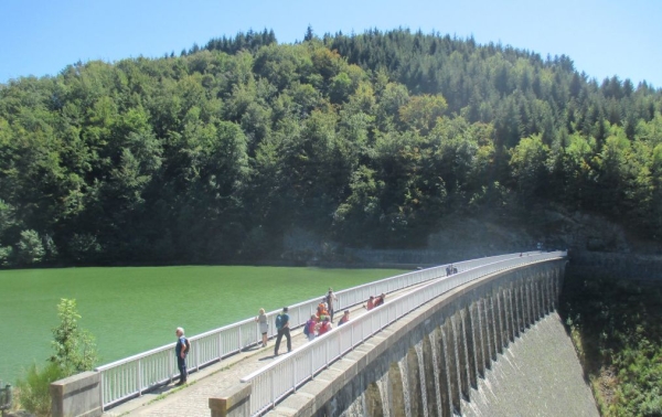
The Cotatay Dam, built from 1900 to 1904, supplies drinking water to Le Chambon-Feugerolles. Previously, a wood-turning workshop, where wooden handles were made, stood in its place. Downstream, rifle barrels were turned. Upstream from the dam, the ruins of a silk mill remain, which employed thirty-five female workers from Saint-Romain until 1934.
Beech, pine, wild cherry, oak, and chestnut trees fill the valleys. The open climb towards the agricultural village of La Chomette offers a superb panoramic view of the Saint-Étienne basin, dotted with a few slag heaps.
The starting point is at the crossroads of Rue Honoré d'Ufré and Rue du 19 mars 1962.
Take Rue du 19 mars 1962, then the first path on the right until "Jamelard", in front of an old farmhouse. From this spot, you'll discover a beautiful view of Le Chambon-Feugerolles. Follow the Lignon aqueduct to the Cotatay Cave. Walk up the valley to the dam wall (you can easily walk around it, about 3 km, crossing the dam to turn clockwise).
At the foot of the structure, take a path to the left that joins the St-Genest-Malifaux road, pass below the hamlet "le Fressinet", follow this path to the Croix du Bessy, at the sharp bend take the path straight ahead, from there rejoin La Pauzière and Rue Honoré d'Ufré until the starting crossroads.
⚠️ Caution, busy road, please be careful.
Hiking Recommendations
Everyone is responsible for their own safety. Therefore, hikes are undertaken at your own risk. Stay on marked trails to preserve fragile areas.
Some general recommendations:
- Check the weather forecast before setting out
- Some routes cross busy roads: Exercise caution
- Keep dogs on a leash
- Do not light fires
- Carry out your trash
- Admire the flowers, do not pick them.
- Tick bites can lead to serious illnesses; for prevention: wear long clothing, use repellents, check yourself upon return, remove ticks using a tick remover without applying anything to it, consult a doctor in case of apparent redness, flu-like symptoms, or if you are an at-risk person.
- For emergencies, dial 18 or 112.