Hiking - Le Martinet
The trail you are about to take highlights the Cévennes forest. Along several points, set out to discover different trees and enjoy the diversity of the landscapes while immersing yourself in the history of the place!
The trail you are about to take highlights the Cévennes forest. Along several points, set out to discover different trees and enjoy the diversity of the landscapes while immersing yourself in the history of the place!
Start: From the parking lot of the restaurant Le Martinet, cross the bridge on the right to reach the beginning of the trail.
(1) The chestnut tree (Castanea sativa) was called the “bread tree” by the Cévenols because its fruits always protected them from famine. A symbolic species, it held a central place in the rural economy of the Cévennes.
(2) Most of the Cévennes chestnut groves were originally planted as orchards, on cultivated land that was carefully maintained. In the plot before you, the regular spacing between trunks as well as the low, rounded shape of the trees attest to its past as fruit orchards, now evolving into coppice woodland.
(3) In front of you, you can see a tower perched on a steep spur. This is one of the remains of the castrum of Saint-Etienne, sometimes called Roqueservière, which in 1052 belonged to the seigneury of Anduze. The term castrum refers to a feudal site made up of both a castle and its fortified village, likely abandoned at the end of the 15th century.
(4) Did you know? 64% of the territory is forested. The forests are young and shaped by the history of the Cévennes. 80% of the Cévennes forest belongs to private owners. But here, you are in an intercommunal public forest managed by the National Forestry Office.
(5) Here, these chestnut trees are managed using the coppicing system: the trees, cut down to the stump every 1 to 5 years, sprout numerous new shoots from the base. These shoots can grow 1 to 2 m in the first year. They are used for basketry, hoop-making, stakes, or firewood depending on the diameter reached.
(6) Since the beginning of the descent, the trail has left the modern track and follows the former “royal” road built from Saint-Etienne-Vallée Française to the Col de Saint-Pierre in the 17th century. At that time, the royal power sought to better control the Cévennes, troubled by religious tensions after the revocation of the Edict of Nantes, which banned Protestant worship. Notice the particular care with which the schist was hand-cut, forming a drainage channel at the base of the rocks.
(7) The name “matorral,” of Spanish origin, covers several local terms referring to scrubland and maquis, consisting mainly of shrubs. Here, one dominant species can be observed: cade, or prickly juniper (Juniperus oxycedrus). Tip: to distinguish cade from the common juniper, also present here, look at their needles! Cade has two white bands on its needles, while the common juniper has only one white band on each needle.
(8) This maritime pine (Pinus pinaster) is balanced on its rock. Thanks to its root system and its adaptability, it has made the most of the schist cracks to seek out water and nutrients.
(9) The banks of the Gardon de Sainte-Croix host typical vegetation of herbaceous plants, shrubs, and riparian trees. This environment, called “riparian forest” (ripisylve), plays an important purifying role. The plants that make it up have high water needs and can withstand regular flooding caused by floods. The riparian forest plays a fundamental role in the river ecosystem.
A trail accessible to all. Picnic area at the trailhead.
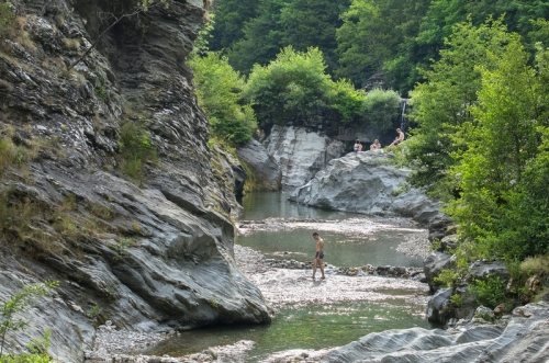
In summer, swimming is possible in the Gardon, accessible on foot from the parking lot.
Adapt your equipment to the day’s weather conditions. Remember that the weather changes quickly in the mountains. Make sure to bring enough water, good shoes, and a hat. Carefully close fences and gates.
The trail you are about to take highlights the Cévennes forest. Along several points, set out to discover different trees and enjoy the diversity of the landscapes while immersing yourself in the history of the place!
Start: From the parking lot of the restaurant Le Martinet, cross the bridge on the right to reach the beginning of the trail.
(1) The chestnut tree (Castanea sativa) was called the “bread tree” by the Cévenols because its fruits always protected them from famine. A symbolic species, it held a central place in the rural economy of the Cévennes.
(2) Most of the Cévennes chestnut groves were originally planted as orchards, on cultivated land that was carefully maintained. In the plot before you, the regular spacing between trunks as well as the low, rounded shape of the trees attest to its past as fruit orchards, now evolving into coppice woodland.
(3) In front of you, you can see a tower perched on a steep spur. This is one of the remains of the castrum of Saint-Etienne, sometimes called Roqueservière, which in 1052 belonged to the seigneury of Anduze. The term castrum refers to a feudal site made up of both a castle and its fortified village, likely abandoned at the end of the 15th century.
(4) Did you know? 64% of the territory is forested. The forests are young and shaped by the history of the Cévennes. 80% of the Cévennes forest belongs to private owners. But here, you are in an intercommunal public forest managed by the National Forestry Office.
(5) Here, these chestnut trees are managed using the coppicing system: the trees, cut down to the stump every 1 to 5 years, sprout numerous new shoots from the base. These shoots can grow 1 to 2 m in the first year. They are used for basketry, hoop-making, stakes, or firewood depending on the diameter reached.
(6) Since the beginning of the descent, the trail has left the modern track and follows the former “royal” road built from Saint-Etienne-Vallée Française to the Col de Saint-Pierre in the 17th century. At that time, the royal power sought to better control the Cévennes, troubled by religious tensions after the revocation of the Edict of Nantes, which banned Protestant worship. Notice the particular care with which the schist was hand-cut, forming a drainage channel at the base of the rocks.
(7) The name “matorral,” of Spanish origin, covers several local terms referring to scrubland and maquis, consisting mainly of shrubs. Here, one dominant species can be observed: cade, or prickly juniper (Juniperus oxycedrus). Tip: to distinguish cade from the common juniper, also present here, look at their needles! Cade has two white bands on its needles, while the common juniper has only one white band on each needle.
(8) This maritime pine (Pinus pinaster) is balanced on its rock. Thanks to its root system and its adaptability, it has made the most of the schist cracks to seek out water and nutrients.
(9) The banks of the Gardon de Sainte-Croix host typical vegetation of herbaceous plants, shrubs, and riparian trees. This environment, called “riparian forest” (ripisylve), plays an important purifying role. The plants that make it up have high water needs and can withstand regular flooding caused by floods. The riparian forest plays a fundamental role in the river ecosystem.
A trail accessible to all. Picnic area at the trailhead.
In summer, swimming is possible in the Gardon, accessible on foot from the parking lot.
Adapt your equipment to the day’s weather conditions. Remember that the weather changes quickly in the mountains. Make sure to bring enough water, good shoes, and a hat. Carefully close fences and gates.