Hiking - The Bozano Refuge
A varied uphill trek, a bit taxing only in the final tract. On the return leg, the route can be modified to include the less frequently traversed "Shepherds' Trail", which circles back to the initial track. The Bozano Refuge serves as a base for some of the best-known climbs in the Maritime Alps.
The route crosses through a multitude of habitats: fir and larch woods, sparse pastures and vast stretches of scree. In the background, the majestic western face of the Argentera, with the characteristic form of the Corno Stella, the epitome of the unconquerable pinnacle.
From the parking lot at the Gias delle Mosche (1592 m), the trail begins on the left (for those coming from Terme) and leads into the Vallone dell'Argentera.
The trail leads up an uphill incline, passing through a lovely copse of firs with few turns. After the initial climb, the trail proceeds uphill in long switchbacks, staying among the firs, which are replaced by larches as the altitude increases. The trail reaches the meadow where the Gias del Saut stands, passing through it on the north side, a few meters above the bottom of the field.
The path rises up to the bowl-shaped pasture above the gias (where there is a striking panorama of the Serra dell'Argentera), and passes through it, staying on the north side once more. Shortly before coming to the ruins of the Gias del Mesa (or Gias del Mesdì, 2070 m, 1 hour and 30 minutes from the parking lot in Gias delle Mosche) the trail forks: the right fork leads to the Bozano Refuge, along the "Shepherds' Trail", and is on the return route. The outward route instead follows the left fork, towards the north.
The path climbs up the grassy slope with a switchback or two, the trail passes through a stand of conifers and surmounts a rise and, near the ruins of a gias, veers northeast. After a long traverse across a scree and a steep climb among boulders and rubble, the path passes by two turnoffs, one after the other. The first, on the left, leads to the Varrone Bivuoac (expert hikers only) and, a little beyond it, on the right, there is the turnoff for the Gias del Mesa and the Gias delle Mosche along the "Shepherds' Trail" (recommended for the return leg).
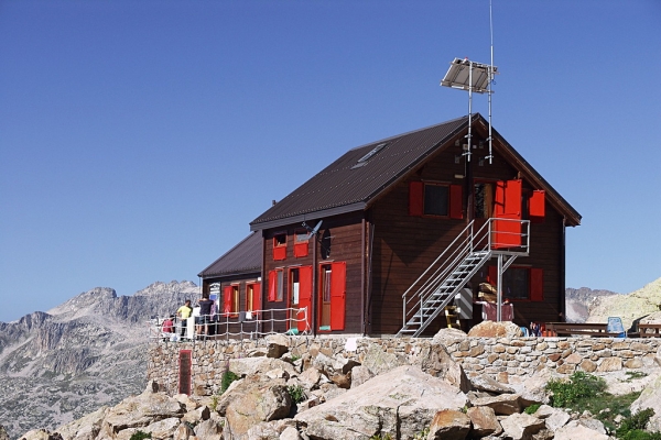
Heading east (towards the Corno Stella), there is a last gueling tract among stones and large boulders. The path passes a last turnoff in a patch of scree leading to the Remondino Refuge, and in a few short meters arrives at the Bozano Refuge (2454 m, 1 hour and 15 minutes from the fork at the Gias del Mesa).
On the return leg, the route turns to the left at the fork, following the "Shepherds' Trail", which leads to the Gias del Mesa. There is a traverse on a scree slope and then the path turns right at the first fork and decends rapidly, with steep switchbacks leading to the remains of the Gias Superiore, in a depression filled with detritic deposits. It then crosses a small stream. Passing by the turnoff on the left, leading to the Remondino Refuge, the path runs northwest and, in a series of tight switchbacks, crosses back over the stream and comes to the Gias del Mesa.
A few meters past the gias the main trail picks up again and leads back down to the parking lot at the Gias delle Mosche (1592 m, 1 hour and 30 minutes from the Bozano Refuge).
The return along the "Via dei Pastori" is less signposted and less frequented than the main path, although it does not present any technical difficulties. Those who prefer can return along the ascent route.