Hiking - The Ardéchois Trail - Burdignes No. 3
This loop takes you to discover magnificent viewpoints over the Vocance valley in the Ardèche Verte region. It passes by the Chirol orientation table, which offers a panorama of the entire Crêts du Pilat, before returning to the village along the ridgeline.
Cross the square by the washhouse (and the stump of the Sully lime tree) and turn right onto the road to Toissieu. Pass the fountain, the cemetery, and the old quarry (view over the valley, the Vercors, and the Alps).
At the junction with the road to Chirol, take the path downhill to the right until you reach Croix Fleurie. Turn left and follow the path above la Petilière (view over the Tramont valley) to the Croix de l’Ane, then continue on the Annonay road, which goes downhill for
1.5 km. At the l’Hermutz junction (the name supposedly means "uncultivated," from the same root as "hermit"), turn left onto the forest path, which climbs for 1 km. At the Y-junction, bear right onto the stony
path heading downhill to the Fontilles crossroads. Climb to the left for 1 km (follow the Ardéchois trail markers).
At the crossroads below Chirol (alt. 835 m), take a sharp left-then-right switchback and climb the very stony path.
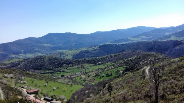
At the Croix de Chirol, the orientation table (at an altitude of 915 m) offers a panoramic view of the southern Pilat, the Alps, the Vercors, Mont Ventoux...). Go down the path on the right, which is lined with wide wooden steps, and turn left onto the trail. At the car park, continue along the road for 1 km.
At the Croix de Beaujon, make a right-then-left turn and follow the path past the Madone before arriving back in Burdignes.
Cross the square by the washhouse (and the stump of the Sully lime tree) and turn right onto the road to Toissieu. Pass the fountain, the cemetery, and the old quarry (view over the valley, the Vercors, and the Alps).
At the junction with the road to Chirol, take the path downhill to the right until you reach Croix Fleurie. Turn left and follow the path above la Petilière (view over the Tramont valley) to the Croix de l’Ane, then continue on the Annonay road, which goes downhill for
1.5 km. At the l’Hermutz junction (the name supposedly means "uncultivated," from the same root as "hermit"), turn left onto the forest path, which climbs for 1 km. At the Y-junction, bear right onto the stony
path heading downhill to the Fontilles crossroads. Climb to the left for 1 km (follow the Ardéchois trail markers).
At the crossroads below Chirol (alt. 835 m), take a sharp left-then-right switchback and climb the very stony path.
At the Croix de Chirol, the orientation table (at an altitude of 915 m) offers a panoramic view of the southern Pilat, the Alps, the Vercors, Mont Ventoux...). Go down the path on the right, which is lined with wide wooden steps, and turn left onto the trail. At the car park, continue along the road for 1 km.
At the Croix de Beaujon, make a right-then-left turn and follow the path past the Madone before arriving back in Burdignes.
Everyone is responsible for their own safety. Therefore, you hike at your own risk. Stay on the marked trails to protect fragile ecosystems.
A few recommendations:
- Check the weather forecast before you leave
- Some routes cross busy roads: Be careful
- Keep dogs on a leash
- Do not light fires
- Carry out your rubbish
- Enjoy the flowers, but do not pick them.
- Tick bites can cause serious diseases. As a preventive measure: Wear clothing that covers your skin, use repellent, check your body upon your return, remove any ticks with a tick remover tool without applying any substance to them, and see a doctor in case of a rash, flu-like symptoms, or if you are in a high-risk group.
- For emergencies, dial 18 or 112.