Hiking - Sainte Blandine - Saint-Appolinard No. 1
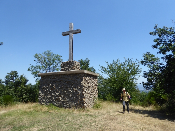
The cross of Sainte-Blandine, standing around 4 m high, was built in 1895 and blessed during a mission.
This cross is said to protect the village from storms. On the edge of the forest, it overlooks the orchards, streams, and the polychrome church tower.
From this natural viewpoint, on a clear day, a magnificent panorama of the Ardèche mountains, the Rhône, and the Alps opens up to the hiker.
The first part of the Sainte Blandine trail is shared with the Sentier des hauteurs (No. 2).
From the Place de la Bascule, get on the Route du Tracol (D503) and follow it for thirty metres towards Saint-Julien Molin Molette. Take the Route du Vernat on the right, until you reach a cross. There, take the leftmost paved road and continue straight on to the summit. When you reach the signpost, the two trails split; turn left. After a few metres, the Sainte-Blandine cross will come into view. There is a picnic area in front of the cross. A short detour to its base will give you a view of the Rhône valley, and in clear weather, you will be able to see the Alps.
The trail continues along the path, straight on to the directional sign. From there, the descent begins. The trail goes straight, across fields, then along the edge of a wood, until you reach the house on the Impasse de Corbine. Go past the house and follow the paved road down to the Route du Tracol, then turn right and go up to the bend, and take the Route de la Bruche on the left. Cross the hamlet of la Chavanerie and, as you leave it, take a path on the right that will lead you down to the Route de St Jacques. Then turn left for a few metres, and at the signpost, get back on the trail to your right, which crosses the stream before a final climb up to the village. Once in front of the church, turn left to return to the Place de la Bascule.
⚠️ Warning, this road has heavy traffic, please be careful.
Everyone is responsible for their own safety. Therefore, you undertake these hikes at your own risk. Please stay on the marked trails to protect fragile environments.
A few recommendations:
- Check the weather forecast before you set off
- Some routes cross busy roads: Be careful
- Keep dogs on a leash
- Do not light fires
- Take your litter home with you
- Admire the flowers, do not pick them.
- Tick bites can lead to serious illnesses ; for prevention: wear clothing that covers your skin, use repellents, check your body upon your return, remove ticks with a tick remover tool without applying any substance to them, and consult a doctor in case of redness, flu-like symptoms, or if you are in a high-risk group.
- For emergencies, dial 18 or 112.