Hiking - SÉRANON - Crêtes du Bauroux
‹‹It's a journey through time, blending history with the natural beauty of the Préalpes d'Azur. The villages of Séranon and Caille transport you to a Provençal atmosphere, the ruins of Vieux-Séranon (13th century) are a living testament to history, and the Crêtes du Bauroux, with their rocky and arid slopes, have served as a refuge since the Neolithic era. At the summit of Bauroux, the view of the surrounding mountains is sublime, preceding the descent to Col Bas via the lush green slope of the Bois du Défens. Magical!›› Charlotte MOUTIER - Photojournalist
From the car park, turn left (trail marker 192) and climb the grassy Chemin de Curnier (GR and PR waymarkers).
1-At the intersection, bear slightly left then immediately right towards the woods. When you reach a paved road, turn right and head uphill. Further up, at a bend, take the grassy path on the left (oratory). 80m further on, follow the trail running slightly below the service track. Emerge onto a path and proceed left.
2-At trail marker 193a, walk alongside the chapel, then at trail marker 193, climb a rocky trail towards Vieux Séranon. When you reach the old ruined village (trail marker 194), descend on the other side and 100m further down, turn right towards the Bauroux summit (PR). Enter the forest. Follow the ridges in the shade of oaks and pines, alternating between flat sections, small climbs and short descents.
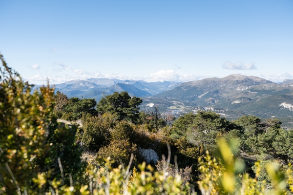
3-At the large pine tree, turn right and, 100m further on, you will reach the Bauroux viewpoint. Retrace your steps, turn right and continue the long, steep and stony climb (PR). This is followed by a rocky section where you may need to use your hands for support. Cross a final descending section then climb one last steep incline.
4-At the summit of Bauroux (1644m), marked by a large wooden cross, continue on a long descent over loose stones, then onto a dirt track with switchbacks through a pine forest.
5-At the water tank, continue on a forest track to the left. At a hairpin bend, follow the footpath towards Col Bas.
6-Cross the D80 road then continue straight on towards Caille (trail markers 182 and 181). Cross the D79 road, then turn right and then left onto the grassy path and continue along a track (caution).
7-Follow the paved road that leads to Caille (trail marker 180). At the church, turn right.
8-Walk alongside the D79 road for several metres, then turn right onto the path to Séranon (caution) (trail marker 197).
9-Follow the grassy track then turn right onto the road and begin a short climb.
10-Continue on a grassy track then on a paved road, always straight ahead, until you reach Séranon town hall (trail marker 196).
The Alpes-Maritimes Departmental Council, as part of its management of the routes registered in the Departmental Plan for Walking and Hiking Itineraries (PDIPR), ensures the maintenance of this trail as well as its signage and waymarking.
You will find up-to-date information on whether this trail is open or closed by consulting the link: Crêtes du Bauroux - Randoxygène
-At Col Bas, be careful when crossing the D80 and D79 roads
-Be careful when walking along the D79 road when leaving Caille towards Séranon, there is no verge for pedestrians
-The route crosses grazing areas; you may encounter flocks or herds on your path.