Hiking - 2-Day Weekend Hike on the Pilat Ridges
Points of interest on the first stage:
Points of interest on the second stage:
Stage 1: LE COLLET DE DOIZIEUX – LE CHAUBOURET (Croix de Chaubouret)
16.5 km 6h 00m Min. altitude: 910 m Max. altitude: 1432 m
elevation gain/loss: +730 m / -480 m
From Collet de Doizieux (945m), take the Parc n°3 footpath (white and brown markers) which climbs opposite the inn towards Crêt de l’Oeillon. The path is a bit steep and very stony at the start, then you'll join a good, much more passable track. Leave this track to the right to continue the ascent, reaching the point marked 1130m (signpost).
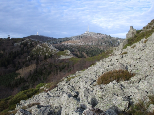
Continue following footpath n°3 (white and brown markers). You will pass La Croix Louis (1214m), then the ruins of l’Hôtel Brûlé, 1258m (in a large clearing). The path then climbs through a chirat (scree slope) to reach the orientation table at Crêt de l’Oeillon (1370m). Follow the white and brown markers carefully as they go up to the right into the chirat (an easier, less steep way to access the orientation table).
Then, descend to the Crêt de l’Oeillon car park (Collet de l’Oeillon, 1318m) to take the Crêt de Botte military road. Follow the signposts to cross all the Ridges (indicated at each subsequent pass) until you reach the massif's highest point: Crêt de la Perdrix (1432m).
From Crêt de la Perdrix, descend to the point marked 1370m, following the GR7 trail (white and red markers). Continue downhill to reach Croix Drevet, near the Jasserie road. The GR7 runs alongside the road for about 200 m, then turns left into the forest to begin the descent towards Les Hautes Gouttes. At the bottom of the path, you will come to a small tarmac road; follow it uphill to the right. At the last houses, the tarmac gives way to a dirt track, and you'll reach the Jasserie road through a beautiful beech forest. Cross it and continue on the GR7 opposite (at the timber yard) to the point marked 1217m (signpost). The GR7 then leads directly to La Croix de Chaubouret (1201m) along a pleasant forest track, which you follow for just over 1 km.
Accommodation:
Gîte Le Chaubouret., at La Croix de Chaubouret
Points of Interest
Stage 2: LE CHAUBOURET – LE COLLET DE DOIZIEUX
14.5 km 5h 00m Min. altitude: 590 m Max. altitude: 1385 m
elevation gain/loss: +580 m / -830 m
From La Croix de Chaubouret (1201m), retrace your steps from the previous day, following the GR7 again to the crossroads with the Jasserie road (1217m) (timber yard).
Here, leave the GR7 and follow the Parc n°9 trail, marked in brown and white. It runs alongside the Jasserie road, crosses it (be careful), and then continues opposite on a stony, uphill path that cuts a corner, rejoining the road which you will then follow towards La Jasserie. The path rejoins the Croix Drevet crossroads and the GR7 trail taken the previous day.
Follow a section of the previous day's route in reverse to arrive back at 1370m. From here, you can either go back up to Crêt de la Perdrix or bypass it by taking the small path opposite through the heather to admire the view from the paragliding launch site on the other side of the road.
Then continue along the road to pick up the GR7 again (at point 1354m) and begin the descent through the meadow (former ski lifts) to reach La Jasserie (1308m).
Go alongside the building and then follow the Jean Jacques Rousseau footpath (footpath n°1, white and brown markers) towards Doizieux.
After a long, quite stony descent, you will reach the hamlet of La Roche. Continue following the Parc n°1 footpath (white and brown), which leads to Doizieux (590m).
In the village, cross the Dorlay river and climb up the other side to reach Collet de Doizieux via a wide forest track, still following the Parc n°1 footpath with its white and brown markers.
If you still have the time and energy, there is an optional additional loop to discover the spectacular Chirat Rochat and its panoramic view – a fine conclusion to this 2-day hike:
3 km 1h 30m Min. altitude: 920 m Max. altitude: 1050 m
elevation gain/loss: +130 m / -130 m
Take the Bois de Neufond forest track below the inn. To do so, follow the main road towards Pélussin for 50 m, then turn left, go past the barrier and continue straight along the track for about 900 m. Be careful not to miss the uphill path on the left, marked in white and yellow, which will lead you to the foot of the Chirat.
Follow the markers carefully, as the path continues in a zigzag up the Chirat and the waymarks are on the rocks.
!!Warning: if the scree slope is wet, the route can be very slippery. It is possible to avoid climbing the scree slope by taking the very steep path at the edge, between the forest and the chirat.
After admiring the panoramic view, the return to Collet de Doizieux is a gentle walk through the forest, following the white and yellow markers.
Points of Interest
- Crêt de l’Oeillon orientation table
- Moorland and summit flora
- l’Hôtel Brulé
- the Chirats
- the Chapelle de Saint Sabin and its panoramic view
Points of interest on the second stage:
- Panoramic views from the Ridges (Crêt de la Perdrix orientation table).
- the Chirats
- Moorland and summit flora
- La Jasserie and its "lost person's bell"
- the village of Doizieux, 15th-century keep
Stage 1: LE COLLET DE DOIZIEUX – LE CHAUBOURET (Croix de Chaubouret)
16.5 km 6h 00m Min. altitude: 910 m Max. altitude: 1432 m
elevation gain/loss: +730 m / -480 m
From Collet de Doizieux (945m), take the Parc n°3 footpath (white and brown markers) which climbs opposite the inn towards Crêt de l’Oeillon. The path is a bit steep and very stony at the start, then you'll join a good, much more passable track. Leave this track to the right to continue the ascent, reaching the point marked 1130m (signpost).
Continue following footpath n°3 (white and brown markers). You will pass La Croix Louis (1214m), then the ruins of l’Hôtel Brûlé, 1258m (in a large clearing). The path then climbs through a chirat (scree slope) to reach the orientation table at Crêt de l’Oeillon (1370m). Follow the white and brown markers carefully as they go up to the right into the chirat (an easier, less steep way to access the orientation table).
Then, descend to the Crêt de l’Oeillon car park (Collet de l’Oeillon, 1318m) to take the Crêt de Botte military road. Follow the signposts to cross all the Ridges (indicated at each subsequent pass) until you reach the massif's highest point: Crêt de la Perdrix (1432m).
From Crêt de la Perdrix, descend to the point marked 1370m, following the GR7 trail (white and red markers). Continue downhill to reach Croix Drevet, near the Jasserie road. The GR7 runs alongside the road for about 200 m, then turns left into the forest to begin the descent towards Les Hautes Gouttes. At the bottom of the path, you will come to a small tarmac road; follow it uphill to the right. At the last houses, the tarmac gives way to a dirt track, and you'll reach the Jasserie road through a beautiful beech forest. Cross it and continue on the GR7 opposite (at the timber yard) to the point marked 1217m (signpost). The GR7 then leads directly to La Croix de Chaubouret (1201m) along a pleasant forest track, which you follow for just over 1 km.
Accommodation:
Gîte Le Chaubouret., at La Croix de Chaubouret
Points of Interest
- Panoramic views from the Ridges (Crêt de l’Oeillon and Crêt de la Perdrix orientation tables).
- the Chirats
- Moorland and summit flora
Stage 2: LE CHAUBOURET – LE COLLET DE DOIZIEUX
14.5 km 5h 00m Min. altitude: 590 m Max. altitude: 1385 m
elevation gain/loss: +580 m / -830 m
From La Croix de Chaubouret (1201m), retrace your steps from the previous day, following the GR7 again to the crossroads with the Jasserie road (1217m) (timber yard).
Here, leave the GR7 and follow the Parc n°9 trail, marked in brown and white. It runs alongside the Jasserie road, crosses it (be careful), and then continues opposite on a stony, uphill path that cuts a corner, rejoining the road which you will then follow towards La Jasserie. The path rejoins the Croix Drevet crossroads and the GR7 trail taken the previous day.
Follow a section of the previous day's route in reverse to arrive back at 1370m. From here, you can either go back up to Crêt de la Perdrix or bypass it by taking the small path opposite through the heather to admire the view from the paragliding launch site on the other side of the road.
Then continue along the road to pick up the GR7 again (at point 1354m) and begin the descent through the meadow (former ski lifts) to reach La Jasserie (1308m).
Go alongside the building and then follow the Jean Jacques Rousseau footpath (footpath n°1, white and brown markers) towards Doizieux.
After a long, quite stony descent, you will reach the hamlet of La Roche. Continue following the Parc n°1 footpath (white and brown), which leads to Doizieux (590m).
In the village, cross the Dorlay river and climb up the other side to reach Collet de Doizieux via a wide forest track, still following the Parc n°1 footpath with its white and brown markers.
If you still have the time and energy, there is an optional additional loop to discover the spectacular Chirat Rochat and its panoramic view – a fine conclusion to this 2-day hike:
3 km 1h 30m Min. altitude: 920 m Max. altitude: 1050 m
elevation gain/loss: +130 m / -130 m
Take the Bois de Neufond forest track below the inn. To do so, follow the main road towards Pélussin for 50 m, then turn left, go past the barrier and continue straight along the track for about 900 m. Be careful not to miss the uphill path on the left, marked in white and yellow, which will lead you to the foot of the Chirat.
Follow the markers carefully, as the path continues in a zigzag up the Chirat and the waymarks are on the rocks.
!!Warning: if the scree slope is wet, the route can be very slippery. It is possible to avoid climbing the scree slope by taking the very steep path at the edge, between the forest and the chirat.
After admiring the panoramic view, the return to Collet de Doizieux is a gentle walk through the forest, following the white and yellow markers.
Points of Interest
- La Jasserie and its "lost person's bell"
- Traditional rural architecture, Jarez farmhouses made of schist...
- Views over Doizieux, the Dorlay dam, and the Gier valley...
- the village of Doizieux, 15th-century keep
- the Chirat Rochat and its panoramic view
Everyone is responsible for their own safety. Therefore, you undertake these hikes at your own risk. Please stay on the marked trails to protect fragile environments.
Some useful recommendations:
- Check the weather forecast before you set off
- Some routes cross busy roads: Be careful
- Keep dogs on a lead
- Do not light any fires
- Take your rubbish home with you
- Admire the flowers, do not pick them.
- Tick bites can cause serious illnesses. To prevent them: wear long clothing, use insect repellent, check yourself upon your return, remove ticks using a tick remover without applying any substance to them, and consult a doctor if you see any redness, experience flu-like symptoms, or if you are in a high-risk group.
- For emergency services, dial 18 or 112.